Sunday, March 20, 2011

Trip Report - Gunung Nuang


Huge Turnout..

It was a huge turnout for the Nuang Hiking Trip. A total of 18 hikers ! 

River crossing - this is the widest river crossing- the bamboo bridge was not there during the my last trip - it may not be there when you come and visit again... so you are not supposed to id this river crossing using the bamboo bridge


contradictions ! Expensive Columbia socks & Kampung addidas ??

So dirty !


Group photo at Camp Pacat


Everyone started out very in high spirits and in great anticipation. G. Nuang is a notorious mountain amongst season hikers in Klang Valley, it has almost everything that you would expect in a real hardcore hiking trip... watercrossings, endless kilometers of monotonous walking along 4WD, steep inclines, muddy & slippery trail, exposed roots, huge elevation gain and confusing trails.

We were joined by two superfit athlete - Rothman Fong & Lim Fang Woei (marathoner)
Our regular guest stars Derek Lim and Sheau Huey (who took an overnight coach all the way from Kulim, arrived on Saturday morning 4:30am) and Juliet Lim & Family and Albert

Post trip analysis

Actual Time taken for the entire trip was around 10 hours. This is a really good training and conditioning. For Mt Kinabalu trek, it would be more or less the same duration on both days. Congratulations, all of you did well and I can see that even at the end of the journey, everyone still has some energy left.. and it is good sign. For Ming, Mien and Grace, your fitness levels have improved tremendously since the first training. Keep it up !!

The toughest part of the trek was from Lolo Camp to Pacat Camp. Largely due to the wet season and the trail turned muddy and slippery. The elevation gain of this section around 460 meters.. From 560 meters (Lolo Camp) to 1020 meter (Pacat Camp). We missed the target of completing the section in 1hr30min when we finally completed it in 2 hours.

It was really fortunate that regular hikers Rothman and Derek were around to assist, otherwise it would be a heavy responsibilities and a high risk for me to guide such a large group of people to Nuang. It would have been much more manageable if the size of the group is around 6-10 pax, if everyone is first time to Nuang.

Food - the type and variety of snack we took with us during this trip was good. We had dried cranberries, assortment of high energy nuts, breads, chocs, energy bars etc.. Probably one thing food missing was Dates. which has one of the highest energy content for fruits/nuts.

The strategy of waiting and regrouping at the end of 4WD road, as well as staying close together during the trek through waterfall area turned out to be a crucial one. Otherwise, we might have a few person walking up the wrong trail at Lolo Camp.. ! This would have been a real headache for me !

It was also a blessing that there were no serious falls/incidents.

The target timing for each sections were : (a) 1hr30min to complete 4WD road (b) 40min to complete River crossings/waterfall area and (c) 1hr30 min to Lolo Camp to Pacat Camp.


Our assistance guides - Derek and Rothman. 

Leech bite - guess who leg ? Rothman has the best way to prevent this !


Looking Pretty ... doesn't look like someone was has just climbed 800 meters, thru muddy terrain !

Friday, March 11, 2011

Gunung Nuang - Training.

Gunung Nuang is visible from most places in KL, on a clear day. It is a located to the right from Genting Highlands. It has unique twin peak..

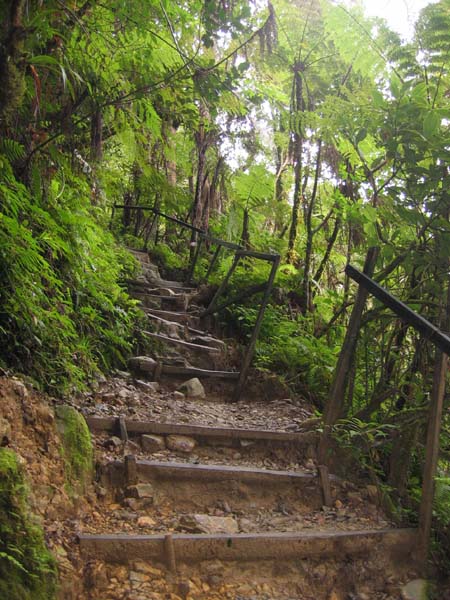
The forest is a bit surreal, a bit mossy type - Cloud Forest- from pacat to summit
Gunung Nuang is located near Ulu Langat, Selangor. There are two common entrance to G. Nuang. From (1) Pangsoon Trail, Ulu Langat and (2) Janda Baik Trail.

I have lost count how many times I have hiked Gunung Nuang, probably about 18 to 20 times.. However, I have never tried the Janda Baik Trail. Always it is via Pangsoon

For most of my past Mt Kinabalu team training, we will always have one training in G. Nuang. In part becuase the level of physical challenge of hiking Gunung Nuang is about the same as climbing Mt K.

From my own estimates (based on my hiking time), the effort of climbing G. Nuang in a single day from Pangsoon entrance carpark all the way to the summit of Nuang 1492 meter is take about the same effort as climbing Mt Kinabalu from Timpohon all the way to just before Sayat Sayat. (7 KM)
Elevation gain of 1200 meters in a day. The profile is only to pengasih (too tired to continue to summit)
The horinzontal distance is not too accurate - total distance is about 10 km (to summit)
The trail can be divided in four main sections

(1) 4WD road - about 5 km - this one goes from altitude of 190 meter to 520 meter (approximate)
(2) Waterfall area - about 1km - campsite, plenty of river crossings, and many places you can get lost !!
(3) Kem Lolo to Pacat - 600 meter elevation to 1000 meters
(4) Lolo to Pengasih (false peak ) 1000 meter to 1430 meter
(5) Pengasih to Nuang Summit 1430 meter to 1492 meter

Wednesday, February 16, 2011

Mount Kinabalu Terrain

I receive many questions on the condition of the Mt K trail, whether it involves rock climbing, thick vegetation, leech, mosquito etc etc...

I hope the pictures below will provide some answers...

I have never hike the Mesilau Trail before, so I will not be able to give a very accurate description.

Some answers below:-

No leech,
No mosquito
No thick vegetation
No need rock climbing skills - the trek is classified as non technical in Rock Climbing terms
You will not get lost.. everything is well marked... unless you deliberately wonder off the main trail

I would guess that the terrain looks a bit like this for a large part of Mesilau Trail..
 

This is the most common type of terrain - 3 to 4 km along the timpohon trail
 

This is the most common sight along Timpohon trail - (we will descend via Timpohon Trail)
Wooden steps, with handrails, not much difference compared to walking up Batu Caves, all the way from Timpohon gate to Layang Layang Checkpoint, it is somewhat like that.


You will encounter this type of terrain about 2 km to Laban Rata, rather steep, and involves a lot of fancy footwork & balancing.. you training in actual dirt trail will pay off here...

This is the so called "Rope Section" - steepest part of your climb.. trust me.. it looks more difficult than it actually is.. you actually can walk up this "Rope Section" hands free.. the rope is just to give you a sense of security
This section is about 0.8 KM after Laban Rata


After Sayat Sayat hut at 7.2 km, you will be hiking along this kind of terrain. This is known as summit plateau, (The top of Mt Kinabalu looks quite flat in picutre!!) . HOWEVER....the word plateau is really misleading... the slope of the terrain here is about 10-15% !! Try doing a brisk walk of 10% on a treadmill !! At 3900 meter, O2 content is 75% of that at sea level.


This is the terrain, just before the summit..
by now, thin air and lack of sleep and exhaustion will be your major concern..  


View from the summit

This guy is Kilian Jornet, winner of 2009 Mt Kinabalu Climbathon, up and down in 2hr40 min.. he wore a sleeveless T shirt, shorts and trail running shoes...


Monday, January 24, 2011

Apek Hill - Trip Report

Everyone looking good and Smart !!

Amazing, everyone turned up early at our meeting point - Petronas Station. On the dot at 8:30am, we left petronas station heading towards the Trail head at Cheras Awana.


Group Photo at the Summit !
Henry, Ming, Peter, Lim, Grace, Sow Keng, Goh (Standing)
Wei Hang, Edwin and Justin 


Yiyo !! this is not like gasing !!


As for the trip, it turned out that it was much tougher than Gasing Hill... And I rated both at 1 star... Apek aka Bukit Putih aka Bukit Segar aka Bukit Saga.. is actually slightly tougher than Gasing.. If it is not too confusing, i would have rated it at 1.35 star, if gasing is one star difficulty.

By looking at the elevation profile alone, it is an almost one way up,

We set a target of summitting in 50 min, .. and everyone managed to summit within 54 min.. Still a very good achievement, considering it is the first serious climb for most of us..It is a total of about 330meter evelvation gain and a total distance of 5.2KM (up and down).


On the way down.. everything is easier

The climb to Apek hill give us an idea what it would be like to hit the slope continuously. In Mt K, the slopes are about the same or slighly gentler gradient, only longer in distance. This is compensated by beautiful view and proper rest stops.

There is even a small section in Apek Hill where we have to use ropes to haul ourselves up. This is quite similar to the challanges you will encounter on the 2nd day our our climb, where there will be some rope sections.

If you go to Apek Hill for training every weekend, and you join one or two of the longer climb such as Gunung Angsi or Gunung Nuang, you will be very well prepared for the Mt K challenge.

As for buying gear, especially outdoor clothing, rain jacket, etc.. I would suggest the following places to shop

Park your car in Bangsar Village 2 shopping centre. Within walking distance there are three outdoor equipment shops:-

(1) World of Sports in Bangsar Village Shopping Complex
Salomon and Columbia brand of ourdoor cloths

(2) Lafuma Shop, in one of those shoplots
Lafuma brand and some other really serious outdoor hardware - excellent sales staff and can bargain somemore

(3) One more outdoor shop, along the same row as MacDonald.. can't remember the name..
This one carries slightly more common outdoor products (cheaper as well)

As for me, I have been using a trusted windbreaker for all my previous trips to Mt K. It is quite thin, light, and made of synthetic material, does not get wet and can double up as a raincoat. Another good thing about my jacket is it can be folded up into  small package and therefore does not take plenty of luggage space.
Purchased in US for about USD 80.

My trusted jacket.. been to many places with it, even below freezing !
Notice The most scenic Kinabalu South Peak in background .. same same as RM 1

2009 Team All nicely geared up..
 Notice I use a headcover, and normal trek pants.. what ever clothing you buy, ensure that it does not get heavy and difficult to dry if it gets wet. Material made from cotton such as jeans, etc should be avoided.


Finally.... Wishing everyone Happy Chinese New Year..

Saturday, January 15, 2011

Bukit Gasing - Trip Report

This is really a fantastic start for our training season. Everyone arrived early and all geared up.

Ming, Mien, Henry, Lim, Peter, Sow Keng & Goh


After a brief round of introduction, we started at 8:30am on the dot.
Initially of course there were a lot of conversation about Kampung Adidas, Mt K, etc etc. But soon after we hit the first hill, everyone instinctly focused on the steps and all conversation ceased.

Obviously a walk in the park for some

Mien.. still going strong....

Henry.. proudly showing off his Kampung Adidas

We set a target of reaching the hanging bridge in 45 min.. and we did it ! With about 4 mins to spare.  On the way back, we were a bit more adventurous and took the opportunity to explore a slightly longer trail. Seasoned hikers Goh and Sow Keng even went for a Second Round !!  For the rest of us.. 2nd round was a Raju Restaurant.

On the technical side of the Journey, we have roughly trekked a total distance of about 3.4 km. and had ascended a few hills of about 50meter to 60 meters elevation gain.

For hiking, it is important to have an idea of how it feels like to hike a vertical gain of 100 meters. With this knowledge, during future hiking trips, we will then be able to gauge how long it will take us to reach the next rest area/check point, and hence pace ourselve correctly.

Below is the elevation profile of Gasing Trail(the trail we used going in) , which I recorded a last year using a handheld GPS.

I have indicated on the profile the location of the Hanging Bridge.


Tuesday, January 11, 2011

Ah Pak Hill - Cheras

This is a short but intense hike. The total ascend for this hike is around 330 meters. So if you do the maths, our hike from Poring Hotspring to Laban Rata ( asc 1400 meters ) is about  4 times as challenging.

It is an excellent place for regular training, as it is near to KL/PJ and the terrain is steep enough.  Also it is safe as there are a lot of hikers there throughout the day, especially weekends

According to regular hikers to Ah Pak Hill, it is a maze of trails there, and there are at least 3 known waterfalls.. and surprise surprise a giant tree..


We will meet at at the Petronas Gas Station across the road (Jalan Cheras) from Phoenix Plaza.

If you are coming from PJ, take the federal highway, and go towards Cheras using the East West Link.. which will lead you pass Leisure mall ( on your left). Then you will reach a rather confusing maze of intersection/flyovers etc. This area is highlighted in red in the map below. Just follow the directions to Kajang.

Eventually you will pass Phoenix Plaza ( on your right). A short distance after Phoenix plaza you will soon see some furniture showroom ( left) and eventually Petronas Gas Station(our meeting point) on your left. This is the same road that will eventually lead to Kajang.

Let's be punctual and meet at 8:30 am. It is Thaipusam holiday !!

Google map of the location of the petronas Station:-


Edwin