Monday, April 11, 2011

Hiking in Lantau Island

Went to Hong Kong for a business trip, and took the opportunity to explore some trails there over the weekend.. in preparation for the coming Sabah Adventure Challenge 60km trail race..

I choose a trail that looks challenging enough... 21km in total. with about 1400 elevation gain.. crossing the peak of two mountains in Lantau island - Sunset Peak( around 800 meters) and Lantau Peak (934 meter). Read some blog that someone did it around 3hr 4 min.. so I thought 4 hours was within reach for me..

Wow.. but boy I was wrong.. took a wrong turn and ended upwith a 4 km detour !!

When I finally got back on the correct trail.. it was already 11am , and I was soon hiking on exposed trail, with no tree covers, in scorching mid day sun. !!  And I had forgotten to take my cap/head cover !! Somemore run out of water half way !!

When I reach Ngong Ping, it was still some 5KM of the planned trekking left... but felt defeated already... took a public bus back down to Tung Chung MTR station ... total trekking time was around 4hr 20min...


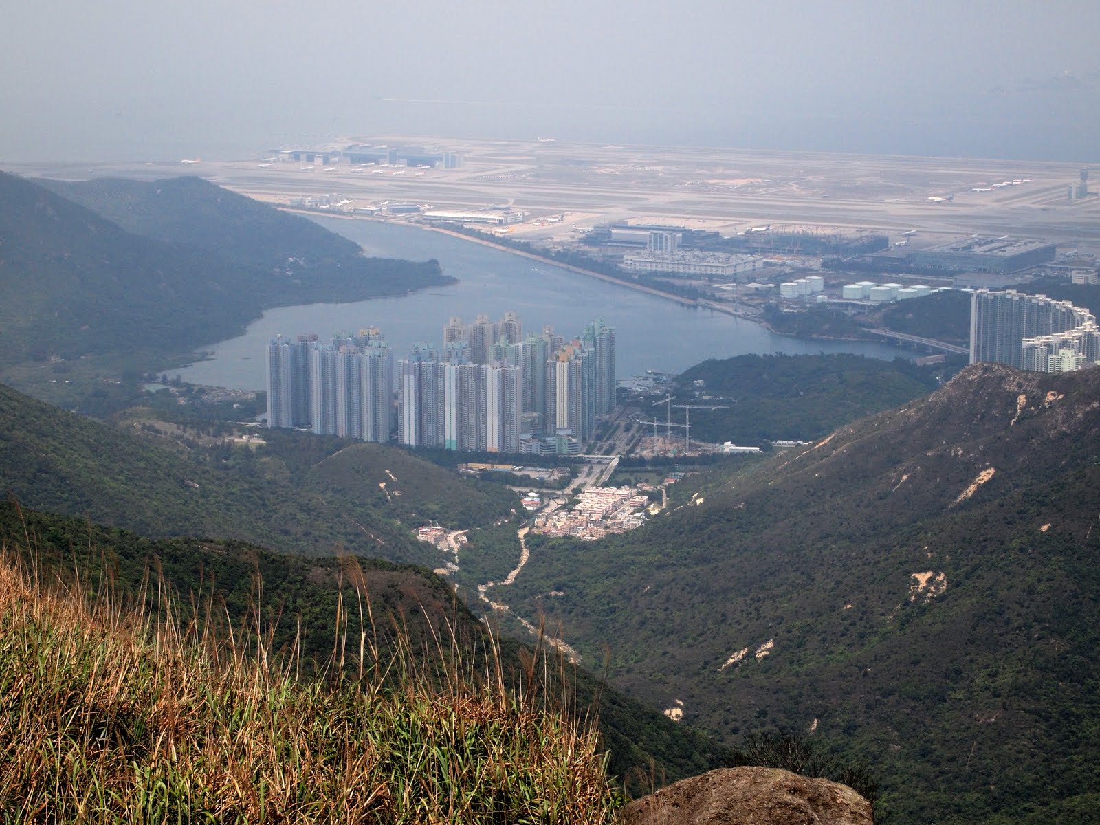
Approaching Sunset Peak

This is the look- hopefully you will not see .. exhausted, sunburnt, thristy, tired & defeated Edwin...

2nd Highest Point in Hong Kong - Lantau Peak 934 meters

I came from there... Sunset Peak !  

Lantau Peak, from Ngong Ping a major spot in HKG, that was where i took a bus back to hotel

Scary elevation profile.. like roller coaster !

Air Hitam Forest Reserve

Introduction
Until recently, Air Hitam Forest Reserve is unknown to the outdoor community, and only a handful of people know of its existence, let alone hike or trek the area.

It occupies around 1,200 hectares .. smacked in the middle of PJ,KL,Selangor Area... The original area used to be as large as 5,000 hectares but unfortunately much of it has been developed int owhat is now Puchong, Kinrara.. Equine Park.. Serdang.. etc. It is still a huge patch of green area !!


I first ventured into the area when I moved to Puchong in 1996. I had only managed to trek around the fringe of the forest reserve... and there wasn't much to see around the fringe area.

It wasn't until Dec 2008 that together with Kelvin ( a regular and pioneer trekker in AHFR) we managed to explore deeper into the Forest Reserve.

There are multiple treks in this Forest Reserve, and much of it remains out of bounds and unexplored by regular trekkers. It is under the stewardship of University Putra Malaysia (UPM) & it is actually out of bounds to public. So trekker usually keep to a loop trail in the area, and seldom venture into other area, where at times, they may bump into UPM staffs/rangers/students.

There are a few beautiful waterfalls/ponds in the area, but we will not be going there this trip...
There are still some WW2 relics, but I have not come across any.. so far...


Pristine stream.. virtually minutes away from civilisation !!


This was taken in early 2009.... very few people has explored the place at that time

My friend KC also wrote a blog and posted some pictures of AHFR during a more recent hike at http://penguin-r2.blogspot.com/2011/01/trail-running-at-puchong-hill.html

Not too long ago, this area made headlines becuase of some Puchong residents spotted a leopard & two cubs.  According to Temuan Orang Asli staying in Puchong Saujana, there are still a few tigers roaming the jungle, and a few sun bears as well.. !!

I have seen wild boars mudbath, monkeys,.. scorpions... that's about all the wild animals...

The trek we are doing is around 4 KM loop trail, and it is an easy hike, somewhat easier than Apek. The highest point in AHFR is around 233 meters only. There are two peaks there.. known since long long ago as Bukit Permatang Kumbang & Bukit Sarang Kuang... (Kumbang = Leopard & Kuang = Quail)

It will be an excellent exploratory hike.. to see our rich heritage... and light training just before our major trip !

Things to Bring

Things to Bring
Essential Packing List
·         Warm clothing
ü      Jacket, sweater, and track bottom, temperature at summit range from 0 to 10 degree
ü      Need not bring winter wear, warm clothing will do, as winter cloth are too heavy and bulky
ü      Head cover- Preferable Ski Mask or baseball cap
ü      Gloves to keep hands warm, normal cotton gloves from hardware shop is fine, I normally use a Gym glove, with fingers exposed

·         Footwear
ü      Hiking boots or Trail Running Shoes / Outdoor Running Shoes / Adventure Running Shoes
ü      Hiking Boots are good, gives extra ankle protection, but a bit heavy
ü      Trail Shoes are light, and provide good grip, but provide less ankle protection
ü      Please ensure that whatever footwear you choose, it is well broken into, to avoid blisters during the actual climb.
·         Raincoat, (if your windbreaker is water resistant, then no need raincoat)
·         Head Torch or Hand Torch with extra batteries
·         2 pairs of Socks, one for wearing on day 1 of climb and one to keep warm at night
·         1.5 litre Water bottle & 750 ml water bottle(for Summit day)
·         Personal Toiletries
·         Backpack
ü      Large Backpack for trip from Park HQ to Laban Rata
ü      Small pack for trip from Laban Rata to summit – one small one for every two person, ladies need not carry any backpack for the journey to summit
·         Lip Gloss – air at the summit plateau is very dry
·         Snack, energy bar such as double decker or Uncle Toby
·         Walking stick / Hiking pole (can buy sticks there ~ RM 5.00)
·         Sleeping bags (if you do not want to use the blankets provided at Laban Rata)
·         Towel, tooth Brush
·          Malaysian Identity Card - for imigration clearance to Kota Kinabalu
Things we bring for everyone
·         Tooth paste, Washing Detergent, Body Shampoo
·         Quick Breakfast for everyone at 2:30 am at Laban Rata
·         Counter pain lotion
·         Simple First Aid
Things to remember
Remember to pack light for the hike- you should be able to pack all your essentials and still carry less than 12kg for the hike from Mesilau Park to Laban Rata and around 5 kg for the trip to summit hike. Ladies can ask the guys to carry your water bottle for the hike up to the summit.
For warm clothing, the temperature fluctuates quite drastically around the summit area, depending on wind condition,   preferable will need something  that you can put on and take off easily (if too warm). For the summit climb, I normally wear a sweater over a T-shirt, Shorts, Track bottom and bring along a wind breaker. On my way down, when it is bright and sunny, I will remove the sweater and track bottom.
You can store your luggage at Park HQ for the things you intend to use in Kota Kinabalu.
You don’t need to bring anything to prevent leech or mosquito., no leech and mosquito for this climb
 For your Airasia Flight, I have paid for extra baggage around 15kg for check in luggage per couple, KL to KK and around 20-25kg per couple for return. Anyway, I will be emailing you your Airasia confirmation.


·         Slippers, if you want to wear something more comfortable in Laban Rata

Sunday, March 20, 2011

Trip Report - Gunung Nuang


Huge Turnout..

It was a huge turnout for the Nuang Hiking Trip. A total of 18 hikers ! 

River crossing - this is the widest river crossing- the bamboo bridge was not there during the my last trip - it may not be there when you come and visit again... so you are not supposed to id this river crossing using the bamboo bridge


contradictions ! Expensive Columbia socks & Kampung addidas ??

So dirty !


Group photo at Camp Pacat


Everyone started out very in high spirits and in great anticipation. G. Nuang is a notorious mountain amongst season hikers in Klang Valley, it has almost everything that you would expect in a real hardcore hiking trip... watercrossings, endless kilometers of monotonous walking along 4WD, steep inclines, muddy & slippery trail, exposed roots, huge elevation gain and confusing trails.

We were joined by two superfit athlete - Rothman Fong & Lim Fang Woei (marathoner)
Our regular guest stars Derek Lim and Sheau Huey (who took an overnight coach all the way from Kulim, arrived on Saturday morning 4:30am) and Juliet Lim & Family and Albert

Post trip analysis

Actual Time taken for the entire trip was around 10 hours. This is a really good training and conditioning. For Mt Kinabalu trek, it would be more or less the same duration on both days. Congratulations, all of you did well and I can see that even at the end of the journey, everyone still has some energy left.. and it is good sign. For Ming, Mien and Grace, your fitness levels have improved tremendously since the first training. Keep it up !!

The toughest part of the trek was from Lolo Camp to Pacat Camp. Largely due to the wet season and the trail turned muddy and slippery. The elevation gain of this section around 460 meters.. From 560 meters (Lolo Camp) to 1020 meter (Pacat Camp). We missed the target of completing the section in 1hr30min when we finally completed it in 2 hours.

It was really fortunate that regular hikers Rothman and Derek were around to assist, otherwise it would be a heavy responsibilities and a high risk for me to guide such a large group of people to Nuang. It would have been much more manageable if the size of the group is around 6-10 pax, if everyone is first time to Nuang.

Food - the type and variety of snack we took with us during this trip was good. We had dried cranberries, assortment of high energy nuts, breads, chocs, energy bars etc.. Probably one thing food missing was Dates. which has one of the highest energy content for fruits/nuts.

The strategy of waiting and regrouping at the end of 4WD road, as well as staying close together during the trek through waterfall area turned out to be a crucial one. Otherwise, we might have a few person walking up the wrong trail at Lolo Camp.. ! This would have been a real headache for me !

It was also a blessing that there were no serious falls/incidents.

The target timing for each sections were : (a) 1hr30min to complete 4WD road (b) 40min to complete River crossings/waterfall area and (c) 1hr30 min to Lolo Camp to Pacat Camp.


Our assistance guides - Derek and Rothman. 

Leech bite - guess who leg ? Rothman has the best way to prevent this !


Looking Pretty ... doesn't look like someone was has just climbed 800 meters, thru muddy terrain !

Friday, March 11, 2011

Gunung Nuang - Training.

Gunung Nuang is visible from most places in KL, on a clear day. It is a located to the right from Genting Highlands. It has unique twin peak..

The forest is a bit surreal, a bit mossy type - Cloud Forest- from pacat to summit
Gunung Nuang is located near Ulu Langat, Selangor. There are two common entrance to G. Nuang. From (1) Pangsoon Trail, Ulu Langat and (2) Janda Baik Trail.

I have lost count how many times I have hiked Gunung Nuang, probably about 18 to 20 times.. However, I have never tried the Janda Baik Trail. Always it is via Pangsoon

For most of my past Mt Kinabalu team training, we will always have one training in G. Nuang. In part becuase the level of physical challenge of hiking Gunung Nuang is about the same as climbing Mt K.

From my own estimates (based on my hiking time), the effort of climbing G. Nuang in a single day from Pangsoon entrance carpark all the way to the summit of Nuang 1492 meter is take about the same effort as climbing Mt Kinabalu from Timpohon all the way to just before Sayat Sayat. (7 KM)
Elevation gain of 1200 meters in a day. The profile is only to pengasih (too tired to continue to summit)
The horinzontal distance is not too accurate - total distance is about 10 km (to summit)
The trail can be divided in four main sections

(1) 4WD road - about 5 km - this one goes from altitude of 190 meter to 520 meter (approximate)
(2) Waterfall area - about 1km - campsite, plenty of river crossings, and many places you can get lost !!
(3) Kem Lolo to Pacat - 600 meter elevation to 1000 meters
(4) Lolo to Pengasih (false peak ) 1000 meter to 1430 meter
(5) Pengasih to Nuang Summit 1430 meter to 1492 meter

Wednesday, February 16, 2011

Mount Kinabalu Terrain

I receive many questions on the condition of the Mt K trail, whether it involves rock climbing, thick vegetation, leech, mosquito etc etc...

I hope the pictures below will provide some answers...

I have never hike the Mesilau Trail before, so I will not be able to give a very accurate description.

Some answers below:-

No leech,
No mosquito
No thick vegetation
No need rock climbing skills - the trek is classified as non technical in Rock Climbing terms
You will not get lost.. everything is well marked... unless you deliberately wonder off the main trail

I would guess that the terrain looks a bit like this for a large part of Mesilau Trail..
 

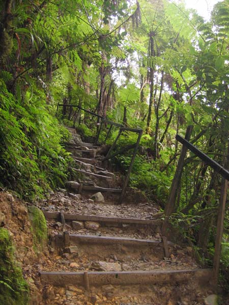
This is the most common type of terrain - 3 to 4 km along the timpohon trail
 

This is the most common sight along Timpohon trail - (we will descend via Timpohon Trail)
Wooden steps, with handrails, not much difference compared to walking up Batu Caves, all the way from Timpohon gate to Layang Layang Checkpoint, it is somewhat like that.


You will encounter this type of terrain about 2 km to Laban Rata, rather steep, and involves a lot of fancy footwork & balancing.. you training in actual dirt trail will pay off here...

This is the so called "Rope Section" - steepest part of your climb.. trust me.. it looks more difficult than it actually is.. you actually can walk up this "Rope Section" hands free.. the rope is just to give you a sense of security
This section is about 0.8 KM after Laban Rata


After Sayat Sayat hut at 7.2 km, you will be hiking along this kind of terrain. This is known as summit plateau, (The top of Mt Kinabalu looks quite flat in picutre!!) . HOWEVER....the word plateau is really misleading... the slope of the terrain here is about 10-15% !! Try doing a brisk walk of 10% on a treadmill !! At 3900 meter, O2 content is 75% of that at sea level.


This is the terrain, just before the summit..
by now, thin air and lack of sleep and exhaustion will be your major concern..  


View from the summit

This guy is Kilian Jornet, winner of 2009 Mt Kinabalu Climbathon, up and down in 2hr40 min.. he wore a sleeveless T shirt, shorts and trail running shoes...